The hike from First to Faulhorn to Schynige Platte is one of the most popular hikes in the Jungfrau region in Switzerland. As you go to the starting point of this hike you will get to enjoy the scenic ride on a cogwheel train, snow-covered trails, rustic mountain huts, alpine lakes, and some of the best views of the Swiss alps. With spectacular views of Lake Brienz or a glimpse of Thunersee (huge lakes next to Interlaken), other crystal clear small Alpine lakes, and Jungfrau massif – the Schynige Platte hike is labeled as one of the best day hikes to trail in the Grindelwald region.
It is quite a long hike, but you won’t regret doing it. The views, nature, the majestic mountains are in your fellowship all hike long.
So pack your backpacks and let’s go on an adventure!
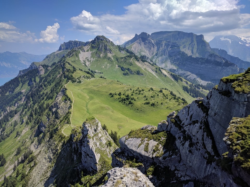
Table of Contents
What you need to know about the hike from First to Schynige
Ok, first things first. A little bit of basic information about the hike so you can decide straight away if it is for you or not.
Distance: 16 kilometers. In the mountains, that’s a lot. That’s like walking 25-30 kilometers on flat ground.
Difficulty: It is not an easy hike. It’s long. I really suggest doing it if you are in really good shape.
Duration: 5-6 hours
Best time to visit: June to October
Elevation changes: you will gain 753 meters and descend 611 meters.
Getting to the starting point: train ticket costs 30 CHF.
Getting out from the finish point: train ticket costs 35.60 CHF.
OR vice versa.
Please check all the latest prices right here: Jungfrau region trains. Check prices to Schynige Platte (one side) and From First to Grindelwald (one side).
It is critical to note that this is a point to point hike and you can do it in any direction based on your taste and preference. You can start even straight from Grindelwald, from Interlaken or from the other side: First.
If you start your trail from Schynige Platte to First you will find it a little more difficult since First sits at a higher elevation, you will have to gain around 150 meters more starting from Schynige Platte. However, if you want to hike it with ease then you should begin at First as you lose elevation (in total you descent more than ascent) and finish at Schynige Platte.
You will have a better view of the Jungfrau mountain range and the lakes surrounding the region. For you to accomplish this you will ride the Schynige train to Wilderswil and a Gondola from First to Grindelwald or vice versa depending on the direction of the hike that you have chosen.
How to Get to Schynige Platte
First of all, you need to get to Interlaken. Interlaken is very easily reachable by train or a car. It is a very well connected city and a very popular Swiss Alps destination. Please check all the latest time schedules and prices right here: Swiss trains.
If you come by car, the best place to park is under Migros shop right here: Rugenparkstrasse 1, 3800 Interlaken, this is what I do all the time I go to Interlaken. OR you can go to Wilderswil (the connection to Schynige Platte starts right here), but parking can be more tricky right there.
Interlaken should be your center point from where you can take the cogwheel to Schynige Platte which departs every hour (sometimes twice per hour). This is one of the most scenic rides and you will come across River Lutschine. You must try to sit on the right side of the train to give you a better view of the area.
Do not be discouraged if the train is full of tourists and crowded: just 5-10 percent will go on a hike with you, and maybe just 1 percent will go the whole way with you to First.
Trains are full of people who go to the top to take some pictures, have lunch and just go back 🙂 Almost all the time when I hike in the Swiss Alps, it’s never crowded. Sometimes I met more people by the huts, restaurants or hotels in the mountains, but I almost even never pass by people, I just meet people sometimes going in the opposite direction.
Ok, back to the train ride: you can peek at the lovely meadows and trails around the area. Swiss cows are the usual fauna right there:)
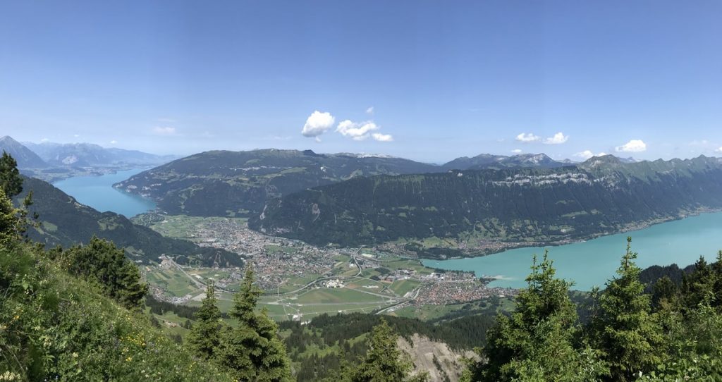
In some cases, you will have an awesome view of Lake Thun and Interlaken. The train will leave the station into the forests and rolls through the meadows to the Schynige Platte. The railway was constructed in the year 1,893 and steam locomotives were utilized at the time.
However, with the advancement in technology electric trains have replaced them. The journey is 7.25 kilometers long and the higher you go the higher the chances of enjoying some of the most exquisite views. You must check the operation dates of the trains and the right time to visit the area to avoid any complication from repair or maintenance of the track.
All information about the train schedules is here: Wilderswil – Schynige Platte connection.
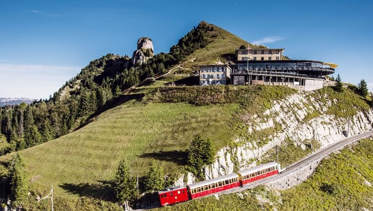
Once you are on the top: it is worth walking to the Schynige Platte hotel at the top of the valley where you can view the valley below on their terrace. Believe me – the views are going to blow your mind straight away AND the hike is awaiting, so even more of that is coming to your iPhone or Android phone:)
The self-service restaurant allows you to re-energize as you begin your hike off the trail. There is also a botanical garden and playground for kids, therefore, you will not have to worry about where your kids will play if you are visiting the area with them. The trail begins at the train station and you can see cows grazing in the area. I love the Swiss cows!
Mostly they are very friendly. Just be aware if they don’t have calves with them – then they can get irritated. Besides, the trail is indicated clearly with signs and you can never miss the trail.
At the trailhead, you will see a sign that will let you know that the time for the last gondola from First to Grindelwald is ready. You have adequate time to decide on what detour you can add to your trail. You can hike from the Schynige to panorama trail. This trail will lead you to Lake Brienz and you will enjoy the views below.
Let’s have a look at the Schynige Platte to First map below:
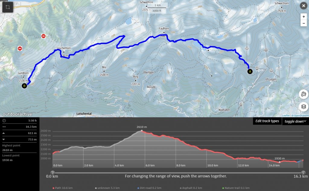
Ok, so you see the highest point here at 2,610 meters? That is Faulhorn (it is actually a bit higher, so you must walk those last meters, it is sitting at 2,681 meters). Ok, so let’s split up the hike into three parts: to Manndlenen Hut, to Faulhorn and to First.
Schynige Platte to Männdlenen Hut
You can hike Schynige Platte to Männdlenen Hut which is a steady uphill work approximately 7.7 kilometers long. There are only a few parts where there is a sudden rise in gradient. Overall, it is not too challenging as you gain around 450 meters in elevation.
In the midway, you are going to past your first peak called Loucherhorn which is 2,230 meters high. If you choose to detour to Panorama Trail then you will have to walk through the green valley traversed with the Rocky Mountains. It is an easy walk and you can take pictures while hiking.
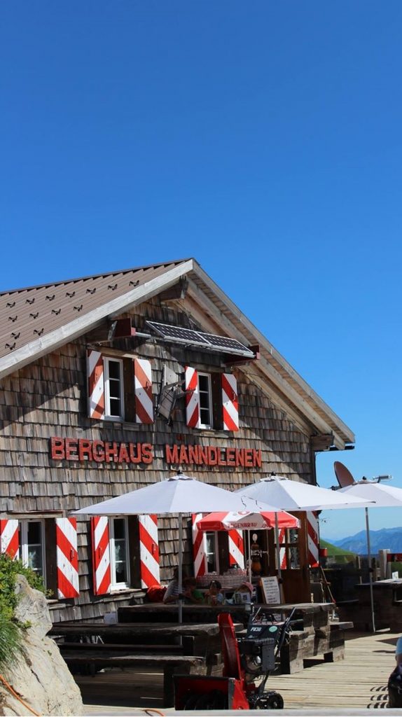
Once you reach the Männdlenen hut, you can definitely rest there as Faulhorn is pretty close and you already should be at least 2 hours into the hike. It has a small restaurant and as well some snacks and drinks can be bought there.
I always suggest people spend a night in the Swiss alps, so actually this hut is a perfect spot to do so if you have more than one day to have the whole adventure. The night up there is not that expensive: around 40 CHF, but it gets more expensive if you order breakfast or something additional. Check all the information of this hut here: Männdlenen Hut.
Hiking to Faulhorn
This trail makes everything interesting as it gets more challenging and you will feel it getting a bit more difficult.
After the hut, the trail heads upwards as you get to Faulhorn. Depending on the time of your hike, you will cross more snowfields (hopefully is not there at the time you are there, as you may need snowshoes or something else to have some grip). It is better if you choose to go hiking during a clear sky day to allow you to have better views of the Swiss alps as well as enjoy the scenic ride to the area.
So from Männdlenen hut to Faulhorn is a bit more than 2 kilometers and the last 340 meters of elevation. Once you reach Faulhorn, there’s as well a hotel and a restaurant, so it’s a perfect stopping point as well.
IF at this point you think that you don’t want to continue to First, it’s a perfect place to turn back and hike back to Schynige Platte as afterward, it would be much harder to return (after Faulhorn hike goes always down).
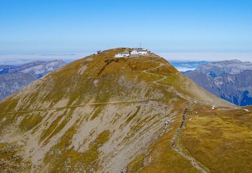
If you want to check out all information about the hotel up there, all info here: Faulhorn Hotel. Actually the rooms are not that expensive as well. A bit more pricey than the hut.
Hike from Faulhorn to First
So now we are on the last leg of the hike. If you are already tired, now it is going to be much easier.
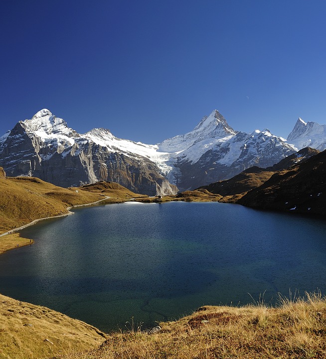
The hike goes down, but one more beautiful treat is waiting for you. It is a beautiful and big Swiss Alps lake called: Bachalpsee. It is the place to take out your camera! It’s gorgeous! It is marvelous!
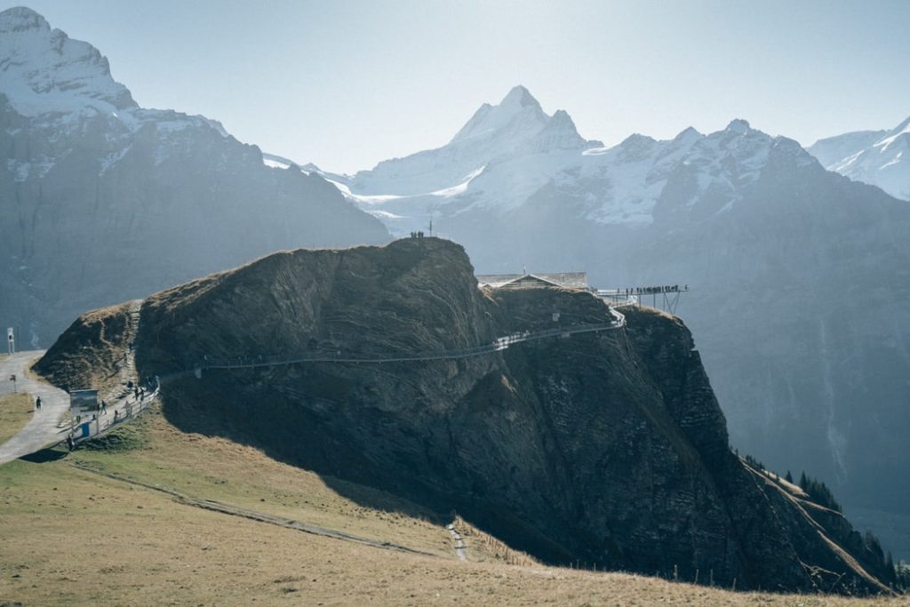
After Bachalpsee you will be relieved as the hike is pretty close to the end and First is an amazing place itself. It’s a tourist place, so you maybe meet more people there, maybe even hundreds as of them as it has this amazing cliff walk.
Once you make it there, you earned to walk there 🙂 It’s peaceful and beautiful up there. It’s one of the really few cliffs walks in Europe.
So here you go! You did it! Long and amazing hike through the Swiss Alps in the Jungfrau region. You won’t regret it.
What you need for the Schynige Platte hike
You will need to have proper hiking gear to make the hike amazing. You will need waterproof hiking shoes because these will give you good traction and will keep your feet dry in the snowy region. Hiking poles are essential, especially in the downhill section.
Besides, do not forget to carry food and at least 2-3 liters water for each to help you re-energize as well as a warm-up during cold (if it’s cold season, take tea or coffee).
As the hike is not short, you can take some plasters for blisters (you don’t want this to ruin the whole Swiss Alps experience).
Take some extra clothing, the best – Goretex jacket. It can be hot and sunny in Interlaken or Wilderswil, but it can get extremely windy and chilly on Faulhorn even in mid-July. Always be ready for changing weather. It may sound impossible, but in the wrong weather in the mountains, you can get completely cold in 10-15 minutes. Better be ready.
If you are not willing to stop and spend money in the restaurants along the hike, take at least 1000 kcal for each. It’s a 6 hours hike, so you need at least one good meal.
Of course, take a camera and phone with you 🙂 Phone – for safety, if you need to call emergency, camera – to make at least 100 beautiful pics 🙂
What’s your favorite section of the Schynige Platte hike? Share your experiences with us!
Pin it for later