Table of Contents
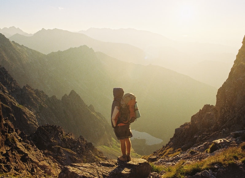
Why is Europe a perfect hiking destination?
The European continent is a perfect location for you to go hiking especially during the warmer seasons because it is lined with rugged coastlines, terrains, breathtaking scenery as well as some of the friendliest and nature-loving individuals, so what are the best hikes in Europe?
If you are looking for a perfect destination where you should go hiking then you should select the European continent because it is filled with numerous spaces where you can enjoy your hiking skills at any season depending on your experience and the location that you are visiting.
Whether you want to head to the snow-covered mountains or you are looking to some of the challenging locations along the coastlines, the European continent guarantees you the best experience possible. As I myself live in Switzerland, I can recommend you countless numbers of amazing hikes with jaw dropping views and life lasting experiences.
Check out my Swiss hikes recommendations:
- Best hikes in Wengen
- Best hikes in Jungfrau Region
- Best hikes in Lauterbrunnen
- Meglisalp hike – leading to old rural village
You can discover hut-to-hut hikes not only in Switzerland, but in other Alps countries as well; hiking routes can include experiences and fun activities such as snorkeling or even scuba diving in some of the seas or oceans in the region. When it comes to choosing the perfect location for you to go hiking, it can be a challenging experience and you should consider all factors to ensure that you have the perfect tour and hiking experience in the region. There are numerous hiking trails that you can choose from depending on the length, level of experience as well as locations that you would like to explore during your vacation in the region.
Spain
Camino Del Rey

Hike duration: 2 to 3 hours
When to hike: Spring and summer season
Difficulty level: easy to intermediate
Distance: 5 miles
This is one of the iconic hiking locations that you should consider during your vacation. Since it is easy to intermediate level I should note that you can hike it with your family and friends. The hike is located in some of the pristine locations in Spain near Malaga. Here you will see the narrow gorges that are donned with beautiful and picturesque surroundings perfect for exploration and relaxation as well. Some parts of the hike are via beautiful bridges which hang on the cliffs.
It is critical to note that if you are going to explore this hike then you should consider that there are places that will require you to hike in areas with high altitudes therefore if you are afraid of heights then you might want to avoid some areas of the trail.
The trail has been explored since the early 20th century and it is rich in history and diversity. It is essential that you have adequate information about the prevailing weather condition as well as the areas that can be tricky to hike especially if you are new to the area. Always ensure that you have your hiking gear to guarantee your safety.
Montenegro

Ladder of Kotor
Length: 13 kilometers
Starting point: Kotor
Time taken to hike: 5 to 6 hours
Difficulty level: Strenuous
When to hike: June to September
End point: mountain top
This is among the most popular hiking trails in Montenegro and you should not miss exploring the area during your visit to the European country. It is popularly known as the ladder of Cataro and has a descent of about 950 meters. While on the mountain top, you can view the most exquisite features that make the surroundings as well as the peninsula in the area. It is a strenuous hiking trail therefore; you should visit this location when you are well prepared.
England
Southwest Coast Path
Length: 630 miles
Starting point: Minehead in Somerset
Time taken to hike: 35 to 56 days
Difficulty level: Extreme
When to hike June to September
End point: Poole Harbor in Dorset
Perhaps this is one of the most exceptional routes that you can choose to go hiking and it is important to understand that there are various challenges along the route that you will have to endure during your hike.
The trail usually attracts a large number of hikers from different parts of the world and you are guaranteed that when you are exploring this area you will have the best experience possible. The route passes through four counties two of which are regarded as UNESCO world heritage sites.
You should not stay on beaten paths just stick to the trail and you will see some of the most unique locations on the planet. This hiking trail has a rich history as it dates back to the centuries when it was used by coast guards use to patrol the coast.
However, over the years it has become one of the top hiking trails. The scenic top vantage points as well as places where it plummets to the sea level where means that you get to a steep decline. You should ensure that you watch out for the waves as you are hiking because they can be pretty strong and huge in the region. There is plenty of options when it comes to accommodation and you will explore the area perfectly during your visit.
Italy
Alta Via 1
Length: 75 miles
Time: 10 days
Starting point: Lago di Braies
Level of difficulty: moderate
When to hike: May through September
End point: La Pisa bus stop
This is a legendary hiking trail that you should try during your visit to the region because you are guaranteed some of the most top experiences in Italy.
The hike features Italian Dolomites (probably on of the most beautiful mountains in the world) and you are going to interact with nature in one of the most pristine locations on the planet. If you are new to multiday hiking then you need to come well-prepared because you are likely to face some challenges during your hike. This hiking trail will take you over a week and a half and you will have enough time to see the beautiful lakes and the beautiful natural surroundings of this pristine location. You should plan adequately for the places that you are going to stay because there are various hotels in the area and you can have a time of your life in the area.
It is accessible to hikers of all kinds and you should not be threatened by the different features that this location has to offer. The elevation gain is gradual in this location and you will have a proper workout as you get to enjoy the crisp mountain fresh air.
Scotland
Quiraing
When to hike: summertime
Start point: carpark in Trotternish
Time: 3 to 4 hours
Distance: 4 miles
Level of difficulty: intermediate
End point: carpark in Trotternish
Perhaps one of the most legendary locations in Scotland that you should consider exploring during your next vacation in Europe.
The country is rich in amazing terrains, mountains, meadows, and grassland areas, which makes it a perfect destination to go hiking. The landscape is impressive and you will have an excellent time during your visit to the region.
The dramatic scenery in the area coupled with the unique Trotternish ride makes this trail one of the most memorable and challenging locations on the planet.
This trail is perfect for avid hikers because you have the chance to push your limit to a different level, but you can definitely achieve it. No worries.
The hiking trail is a loop therefore you can handle it in stages from the car park it will lead you out downhill then uphill and some of the picturesque stone sculptures and nature will take your tour to a different level. The trail is undulating in nature and it is perfect to hike it during clear skies weather because you get to absorb the amazing beauty of the natural surroundings in the region.
Turkey
Lycian way
Length: 540 kilometers
Starting point: Oludeniz
Time taken to hike: 30 to 34 days
Difficulty level: intermediate
When to hike: June to September
End point: Geyikbayiri
This is a legendary hiking trail that you should consider during your visit and it is imperative to note that you should consider hiking it. It flows through the coastline of Lycia serving you with ancient civilization as well as the modern-day architecture, history, and culture of the Turkish people.
The route is well marked and it passes through some of the most iconic UNESCO world heritage sites as well as preserved amphitheaters that have been present for centuries in the region.
The region of Lycia is one of the most iconic places on the planet because it has been ruled by different empires over the years and you should always try to learn something new about the culture and diversity of the people in this region.
You will encounter ancient routes as well as pine forest that is rich in wildlife and plants that can only be found in the region. There are different accommodation options along the way and you are sure that you will enjoy your visit to the region.
England
Mam tor
Length: 5.2 miles
Starting point: Car park in Castleton
Time is taken to hike 2 to 3 hours
When to hike: June through August
Level of difficulty: easy
End point: Car park in Castleton
Perhaps this is one of the most famous hikes that you are going to explore during your trip to the United Kingdom.
The trail is located in the rolling lush green countryside and you can explore the different areas with ease because of the well-marked trails. The circular trail begins from the national trust man tor car park and you can take the hike loop until you arrive to this location again. T
he hiking trail is well marked therefore you will not get lost during your travel to the area and even though there are steep sections you can handle them effectively when you have your protective gear.
Some areas are very slippery and you should have sturdy boots when exploring the region.
Scotland
West highland way
Length: 96 miles
Starting point: Milngavie
Time taken to hike: 6 to 8 days
Difficulty level: intermediate
When to hike June to September
End point: fort William
This hiking trail is regarded as the premier hiking trail in Western Europe because of its popularity among hikers from different locations such as the United Kingdom as well as other European countries.
The hike is not extreme therefore; if you are physically fit, then you can embark on it and explore the different areas.
It is a well marked hiking trail, there are various stages of the trail that are very challenging and your hiking skills will come in handy in such areas.
The path runs through Glasgow and it heads to the northern part of Scotland where you get to interact with beautiful lush green lands, meadows as well as amazing mountain ranges in the region.
The trail is more advanced as you approach the shores of Loch Lomond and you can check out the beauty of the Scottish highlands. The breathtaking scenery in this location will take your experience to a whole new level.
The route is dotted with numerous accommodation options as well as campsites therefore you will never miss something that you can explore during your visit to the area.
Even if you are traveling on a budget, then you should not be worried because there is something for you and you will enjoy your hike in the region. You can plan to hike this trail when the number of people visiting the area is low. This will give you a chance to explore the best in the region.
Spain and France
French way – Camino de Santiago
Length: 485 miles
Starting point: Saint Jean Pied de Port, France
Time taken to hike: 28 to 42 days
Difficulty level: Extreme
When to hike June to September
End point: Cathedral of Santiago de Compostela in Galicia
I have done Camino de Santiago from Saint Jean Pied de Port two times, so if you have any questions regarding preparation, albergues or anything else, just let me know, I will do my best.
You can read more about my experience and tips right here: Camino de Santiago tips.
This is the most popular route that you should consider exploring during your trip to the region as it covers two countries from France to Spain. It is a hiking trail that is mostly focused on individuals who are experienced and can handle the challenging days found along the way.
You can choose different locations where you can start from the French cities ranging from Le Puy, and Paris among others (some people start Camino de Santiago right from their home, as it would make you real pilligrim).
If you are looking for a pristine location where you can relax, hike slowly and embrace nature then this is a perfect spot for you as you are going to cover different regions of Spain: from La Rioja to Galicia and some others.
The path is well-serviced and the people who usually go on this route are exceptional and you will get to interact with people from all walks of life. There are numerous accommodation locations along the trail and you are sure that you will have the time of your life in the region because it is a cost-effective trip.
Since this trail is very long, you must cover the undulating terrain slowly to give you adequate energy to see and explore the rugged terrains and more fascinating villages, towns and cities. You should take your time to interact with people in different parts of this trail as all pilligrims are very friendly and as well the local people will always wish you Buen Camino – have a good way ahead of you!
France and Switzerland
The haute trek
Length: 112 miles
Starting point: Chamonix
Time taken to hike: 9 to 15 days
Difficulty level: intermediate
When to hike: June to September
End point: Zermatt
Talking about fascinating hikes – this one is really worth your time. It begins in Chamonix, probably the most popular mountain village in Europe as it is the location of Mont Blanc (highest mountain in Europe) and leads to Switzerland to the famous Zermatt village where Matterhorn lives (a famous mountain from Toblerone chocolate package).
This is a legendary hiking trail that you should consider during your trip to Europe because it is filled with some of the most picturesque sites on the planet. The hiking trek is legendary because it has some of the finest features that you will only find in this region. You can take the complicated route or choose a much simpler one if you are not well-advanced in mountain climbing.
The crampons, ropes, and other equipment are required during your hike in this route and you should always maintain your safety gear so as to ensure that you enjoy your trip in the area. As mentioned above, the hike moves from Chamonix to Zermatt and this trail is at about 3000 meters above sea level. There are various huts along the way and you can choose to stay in these huts during your hike in the region. The most fundamental thing that you need to do is to ensure that you get all the preparations done before you can visit the different parts of this trail.
France
Mont Blanc hiking trail
Distance: 106 miles
Starting point: Chamonix
Time to hike: 11 days
Level of difficulty: intermediate
When to hike June to September
End point: Chamonix
This is one of the longest hiking trails that you are going to explore in Europe and it is imperative that you take your time to check out the different features that make this hike outstanding.
It is an impressive long-distance hike and it features the Alps and it is often considered as the most picturesque, beautiful and amazing hiking destination on the planet.
The trail is a loop and if you are planning to visit this location then you should come prepared because you are going to see some of the most unique locations in Europe.
The trek takes about eleven days and this will involve you taking sections as well as taking time to relax in different parts.
Since this is a very long hiking trail then you will be required a certain level of fitness.
There are various sections that feature intense ascents, this is where you might find it challenging, and therefore you should come prepared with your hiking gear because this will ensure that you not only reach the most difficult parts on the planet but also explore them easily. The trail can be hard on your joints hence you will need sturdy shoes to make the whole hike.
However, you are guaranteed some of the most exquisite views of the Alps and the surrounding region.
Sweden
Kungsleden Trail
Length: 275 miles
Starting point: Hemavan
Time taken to hike; 30 days
When to hike: July through September
Difficulty level: intermediate
End point: Abisko
If you like more grim weather, some rainy days and adore fascinating Scandinavian nature – that is a place to go. It is definitely a place for me as I love such lush nature with tons of moss.
If you are as well looking for one of the most daunting challenges when it comes to hiking then this is a perfect location for you to explore.
The hike will go through some of the iconic UNESCO world heritage sites and here you can check out the four national parks, as well as the unique hiking trails in the area.
It is imperative to note that you must be well prepared if you are planning to go hiking on this trail because it takes a longer period and it can be very challenging to many people as you will not be always able to sleep in a hut and sleeping in a tent is pretty much unavoidable.
In addition, there are areas that are usually covered with snow hence it can be difficult to hike.
The trail is perfect during the summer period hence you should try to do it during this period (in winter time it is really challenging and rather dangerous to be alone in such an isolated place once it gets extremely cold up there in the north).
You can break the hiking trail into different sections and tackle them according to your level of fitness as well as the availability of time. Always ensure that you wear protective gear when you are hiking on this trail.
France
Corsica
Length: 112 miles
Duration: 15 days
Starting point: Calenzana
Difficulty level: Extreme
When to hike June through September
End point: Conca
This hiking trail is usually marked with red and white markers to indicate that it is a difficult hiking trail.
It is imperative to note that if you are planning to explore the different parts of the trail then you should come prepared because it can be very challenging.
This hiking trail runs from the south to the north or vice versa, depending on how you want to explore it.
It passes through the Corsica mountain range and it is recommended that if you are going to hike in this location then you should have a high level of fitness to ensure that you can tackle the various sections easily.
The steep technical descents will require you to have a better understanding of how to hike complex trails and you should always wear your protective gear to ensure that you get the best from this location.
The best time that you can go hiking in this awesome location is from the month of June through September here you will not have to deal with adverse climatic conditions.
You are not allowed to wild camp on your route and you should plan adequately to ensure that you capture all the various views and the terrains in the region. You should plan adequately before you embark on this hiking trail because it can be overly challenging.
The best way that you can deal with the different hiking trails in the area is to hike it in stages.
You can divide it into 15 stages and try to hike each stage each day and this way you can reach the end point on time.
Greece
Samaria gorge
Length: 10 miles
Start point: Xyloskalo
Time taken to hike 6 hours
When to hike: June through August
Level of difficulty: moderate
This is one of the most adventurous locations on the planet if you are planning to explore some of the most pristine places on the planet.
During your travel to the island of Greece in Crete, you will get to explore the Samaria national park and there is a famous gorge that allows you to see the different areas of the planet giving you the best experience.
Here you will interact with unique fauna and flora that thrive in the region.
The hike is one of the most popular in Europe because it attracts a large number of people.
This hiking trail begins at the top of the gorge and it winds through some of the most unique landscapes in the region before you can reach the top before you begin the exploration of the different unique environments as you see the flowers bloom.
If you are planning to visit the hiking location then it is better during the spring and early summertime when the number of people exploring the area is still few. Since it is an intermediate hiking trail then you should ensure that you have some level of fitness to ensure that you can tackle the challenging trail in the region.
There are various steep and descends which can be tough on your knees and you should ensure that you have proper hiking gear to protect yourself.
Iceland
Laugavegur Trail
Length: 35 miles
Starting point: Landmannalaugar
Time taken to hike 3 to 4 days
Difficulty level: intermediate
When to hike July to September
End point: Thorsmork
Outstanding, daunting, amazing, jaw dropping, crazy, beautiful, eye watering, scary, gorgeous – all these words can describe this hike.
The trek is one of the top-ranked in the world and if you are an avid hiker then you should not miss this trail.
It is imperative to note that you should always go hiking when you are prepared because it can be very challenging and you should be ready when you are traveling to this destination because you will encounter difficult and steep locations.
The changing weather conditions are another factor that you should consider when planning to go and hike in this region.
The hiking trail is well-marked and you will not find difficulty accessing it. However, if you are having challenges then you should go with a tour guide to show you all the areas in the region.
The best time to hike is from July through mid-September. There are numerous months when the trail is filled with snow and therefore you should be careful when moving in such a region.
Portugal
Fisherman’s trail
Length: 78 miles
Starting point: Porto Covo
Time taken to hike: 4 to 7 days
Difficulty level: extreme
When to hike: June to September
End point: Odeceixe
This is an exceptional hiking trail that you should consider when you are going to check the different environments that are amazing in the region.
Western Portugal is one of the most picturesque locations on the planet and you can check out the two trails. The hiking trail is well marked therefore you are sure that you will have an easy time hiking in the region.
You are required to have a certain level of fitness because this is an advanced hiking trail and you should look forward to checking out some of the most exquisite features in the region. The trail was initially used for accessing the beaches and fishing route, however, you should ensure that you explore the region because it features sharp falls and rises.
There are numerous fishing towns in the area, the line is filled with steep rocky cliffs, turquoise blue waters, and amazing beaches hence, you are going to enjoy your hike in the area.
You should always ensure that you have proper hiking gear to give you the best experience possible. This hiking trail is exceptional because it is marked with blue and green markings hence it is easy to explore when moving in any direction. There are various campsites along the way hence you can pitch a tent in one of these locations.
If you are new in this location then it is recommended that you explore with a tour guide. It is often divided into five stages to ensure that you can finish the stage in one of the town areas hence access accommodation and meals.
Austria
Berlin high trail
Length: 53 miles
Starting point: Finkenberg
Time taken to hike: 5 to 8 days
Difficulty level: Extreme
When to hike: June to September
End point: Finkenberg
This is one of the most popular hiking trails in Austria and the German region. T
he trail is rated as an extreme in particular locations, therefore, it is imperative to note that you will need an advanced level of fitness to explore the region.
Berlin high trails begins from a tiny village in Finkenberg and it is a loop therefore this village is still the final location that you will reach. It takes you over an amazing trail that features mountains, escarpments, and peaks which pass from over 6000 and 3000 feet above sea level.
This means that the region is rich in diversity and during your trip; you will see some of the most amazing features of Austria.
There are numerous huts along the way and you will enjoy your time in the region because you get to explore some of the unique features that make this trail historical.
The route is usually open from June through October and you can choose a perfect time for you to explore the trail while it is still warm. You can divide the hiking trail into sections to allow you to hike from one location to another with ease and interact with various locations with ease as well.
Portugal
Pico de Arieiro Trail
Start point: Pico de Arieiro
Length: 7 miles
When to hike in the summertime
Time taken to hike 4 hours
Level of difficulty: extreme
End point: Pico Ruivo
This is one of the most unique hikes that you should take during your vacation in Portugal.
You are going to enjoy the majestic views of the Madeira Islands and check out the trail head, which leads to the mountains. The backdrop of this hike is exceptional and you should ensure that you explore during your visit to the region.
Since the hike stands at 1500 meters above sea level then you are going to be walking in the clouds. It is an exceptional feeling and view when you are hiking in this region.
The area is usually heavily trafficked especially during the summer period, therefore you should plan effectively to ensure that you visit the area when the population of hikers is low.
There are areas where mountain ledge walking is involved hence you should be ready to tackle these difficult areas of the trail.
There are handrails and you should always ensure that you have protective gear when you are exploring the areas.
The hike requires a higher level of fitness and you should be physically ready to do it.
France and Spain
Cami dels Bons Homes
Length: 118 miles
Starting point: Foix, France
Time taken to hike: 8 to 16 days
Difficulty level: intermediate
When to hike: June to September
End point: Berga, Spain
This is an historic hiking trail and you should ensure that you have explored it during your travel to Europe because you get to interact with some of the most pristine locations on the planet and people hiking it.
The way of good men as it is popularly known moves from France to Spain and currently it can be hiked in both direction.
The name of the trek came from Catalan, which is mostly spoken at the end of the trail and in some regions of the Pyrenees in France. The route is clearly marked therefore you are not going to find any challenge if you intend to explore during your vacation in Europe.
Here you will attain an elevation gain of up to 8000 feet and this trail will require you to have some level of fitness to handle it perfectly.
You should ensure that you have proper hiking gear to enjoy your trip in the area and deal with some of the challenging areas such as mountainous, rocky, and sharp climbs.
There are giant trees in the Catalonia region, which marks the end of the hike, and you can explore the city of Berga in Spain. This hiking trail is well-marked and has all the relevant information that you need to hike it.
Norway
Trolltunga
Distance: 16.8 miles
When to hike: summer period
Starting point: Mågelitopp
Duration: 10 to 13 hours
Time to go hiking: June through August
Level of difficulty: extreme
End point: Mågelitopp
The Norwegian terrain is one of the unique on the planet and during your travel to the region; you are going to see some of the most picturesque locations on the planet.
The area is located at 1100 meters above sea level and there are rock formations, undulating landscapes as well as crystal clear lakes around which draws many people to come and hike in this region.
The journey to this region can be quite challenging and it is important that you ensure you have the best experience possible in the region because you are guaranteed exhilarating activities that will take your adrenaline rush to a new level.
You can complete this hike in a single day, however, if you do not intend to push your limits then you can take it several days depending on your level of fitness. Since it is a loop, your starting point will be the endpoint as well.
There are guided tours in the region and you can use them during your visit to the area.
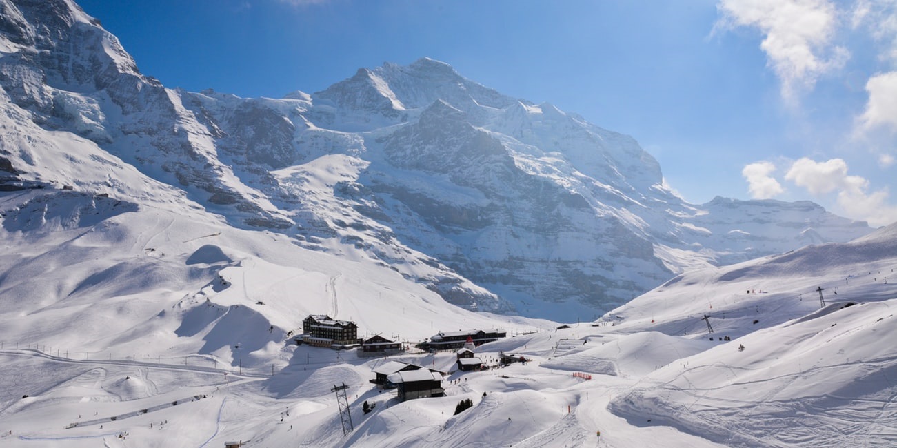
Switzerland
Kleine Scheidegg
When to hike: summer period (winter with snowshoes)
Starting point: Grindelwald
Duration: 3 – 4 hours
Best Time to go hiking: June through August
Level of difficulty: medium
End point: Kleine Scheidegg
Kleine Scheidegg is a picture-perfect mountain pass that connects Grindelwald and Lauterbrunnen in Switzerland. It is a popular hiking destination due to its scenic and easy-to-reach location.
The hike from Grindelwald to Kleine Scheidegg is relatively short, taking about 3 – 4 hours to complete. The trail offers stunning views of the surrounding Alpine landscape, including the iconic trio of peaks, Eiger, Mönch, and Jungfrau.
Along the way, hikers can also appreciate a variety of flora and fauna, such as alpine flowers, marmots, and even ibexes in the wild. Moreover, at Kleine Scheidegg, hikers can enjoy a variety of activities, including exploring the restaurants and souvenir shops, taking the cogwheel train to Jungfraujoch or Wengen, or simply soaking up the magnificent views.
Overall, Kleine Scheidegg hike from Grindelwald is an excellent option for hikers of all skill levels looking for a scenic and rewarding outdoor experience.