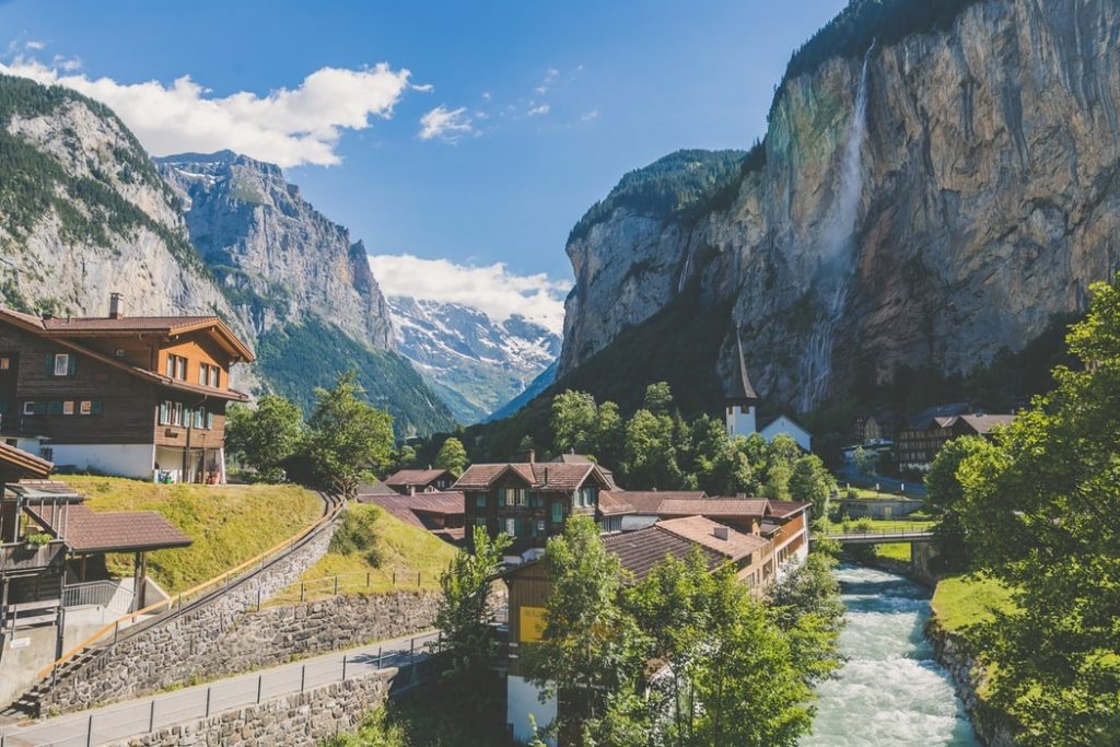
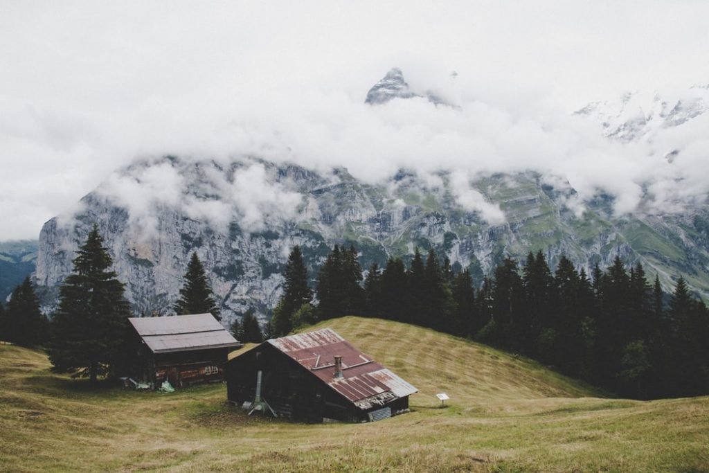
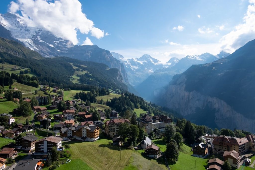
Lauterbrunnen is maybe the most filmed, pictured, and Instagramers beloved village in the Swiss Alps. On top of that, there are various hiking trails in Lauterbrunnen. It features old Swiss buildings, narrow streets, huge mountains all around and most important – a huge waterfall which from the far looks like is falling into the village. Staubbachfall waterfall is falling 297 meters! That is indeed impressive.
So let’s have a look at what can you do in Lauterbrunnen and where can you hike over there. There’s plenty of possibilities for you if you are looking for a hiking adventure, just be aware: all of them are pretty steep. Lauterbrunnen is in the valley surrounded by huge mountains, so the hikes, especially in the beginning are pretty hard, but once more and more views uncovers – every drop of sweat will be worth it.
Table of Contents
How to Get to Lauterbrunnen
Lauterbrunnen sits in the middle of the Swiss Alps right in the Jungfrau Region and very close to one more very popular location Interlaken and Grindelwald.
If you are coming to Lauterbrunnen by car, it’s very easy, no difficult alpine drive to get there. There’s plenty of parking places, but I recommend the big one just right at the beginning of the city right here: Gütli 481, 3812 Wilderswil.
There’s a huge parking building with all the new paying systems. You can find actually more parking places in Lauterbrunnen, even some private, but you may have to pay cash, but it can be cheaper.
Some distances from the bigger cities:
Zürich -> Lauterbrunnen is 138 km
Basel -> Lauterbrunnen is 163 km
Bern -> Lauterbrunnen 67 km
If you would like to come to Lauterbrunnen by train/bus, no problem. Lauterbrunnen is reachable by buses and probably the bus will be coming from Interlaken. But you can reach Interlaken from all over Switzerland by train.
Check out all the latest time schedules and ticket prices here: Swiss train tickets.
6 Majestic Hiking Trails in Lauterbrunnen Region
As Lauterbrunnen is right in the middle of the Swiss Alps, there is quite a lot of hiking trails around it; many places to visit; many mountain peaks to see.
I would like to tell you about my favorite Lauterbrunnen hikes. So even if you spend more than one day in Lauterbrunnen, you will definitely have what to do 🙂
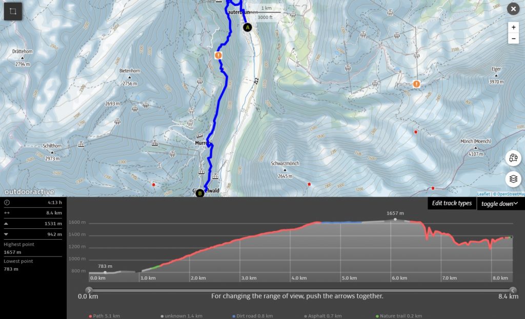
1- Lauterbrunnen to Mürren Hike
Mürren is a very nice location right on the cliff right above Lauterbrunnen. It’s a very nice small Swiss village with a ski resort.
The hike, in the beginning, is very steep, especially the first 2-3 kilometers. After around 1 kilometer you will see an old building (it is or was probably for keeping hay) with a bench, so you can rest right there a bit as the hike is really hard.
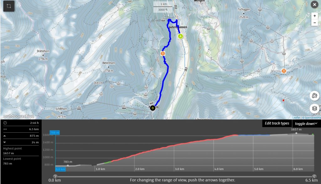
As you can see from the picture above, the whole hike is just 6.5 kilometers (depending on where you start in Lauterbrunnen), but it takes almost 3 hours and you are going to gain more than 850 meters in elevation.
After 4 kilometers of the hike, you will get into a flat path that goes almost with no elevation change, so the last couple of kilometers will be just an easy walk and if the trees don’t cover it too much, the view is very nice to the mountains up there. There are white peaks all year round.
In summertime in Mürren, there are not very many places open, so I would take my own food and water.
If you feel tired at the end of the hike, you can take a cable car to Stechelberg and then a bus to Lauterbrunnen.
If you walk back, it will be a much shorter hike back, as you go down all the time, maybe 2h or less. So all the hike is up to 5 hours. Also, if you’re up for camping in the wilderness and would love to spend more time in this stunning nature, there are options. Generally, Lauterbrunnen offers the best camping spots in Switzerland and you can easily pitch your tent with stunning views in the morning.
In my Mürren hiking experience, you can see my hiking experience as well as some majestic photos of beautiful landscape.
2- Lauterbrunnen to Kleine Scheidegg Hike
Kleine Scheidegg is one of the most popular places around Lauterbrunnen and it’s very easily reachable from Grindelwald. You can check out my hike: from Grindelwald to Kleine Scheidegg.
Kleine Scheidegg is a bit higher than Mürren, so the hike is going to be harder and longer. Kleine Scheidegg sits at 2061 meters so you will have to climb more than 1300 meters in one day.
Let’s have a look at the hiking trail map below:
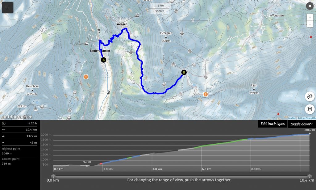
This hike is more than 10 kilometers long and would take you more than 4 hours one way. On your way you are going to cross a very popular destination: a Swiss village called Wengen. You can have a rest or a cup of coffee right there, to keep you full of energy before continuing later.
Kleine Scheidegg is a perfect place to have a rest as it has restaurants, shops, and hotels. It’s very well developed and much fun up there. You can even take a train to Grindelwald from up there, but better let’s talk about doing an ultimate hike from Lauterbrunnen to Grindelwald.
Once you start to walk back to Lauterbrunnen from Kleine Scheidegg, it will be much easier as all the time you will go down. So the walk down shouldn’t be longer than 3 hours. So in total, you are going to do 20 kilometers and 7 hours of walking. That’s a long hike in the mountains, so pace yourself, have food, have water, and relax. There’s no hurry.
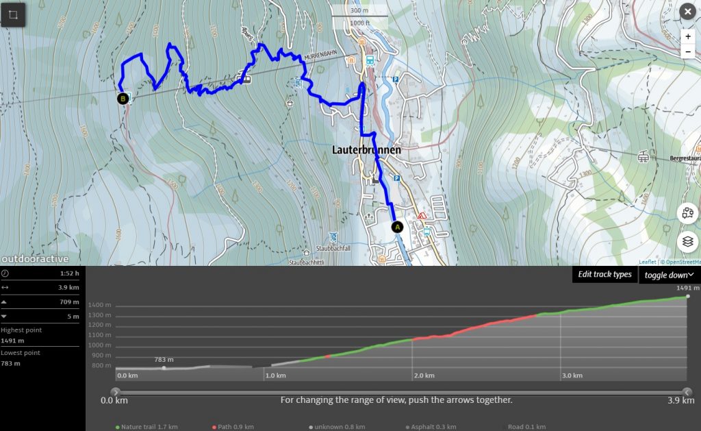
3- Lauterbrunnen to Wengen Hike
I have just mentioned that if you decide to hike to Kleine Scheidegg, you are going to cross Wengen village. That’s a very sweet small village on the mountain meadows.
So the hike to Wengen is much easier, faster, but still pretty steep 🙂 There’s no way around it if you hike in Lauterbrunnen and want to reach places higher: trails are going to be steep. It’s not steep only if you walk along the valley.
Ok, so let’ have a look at the map below:
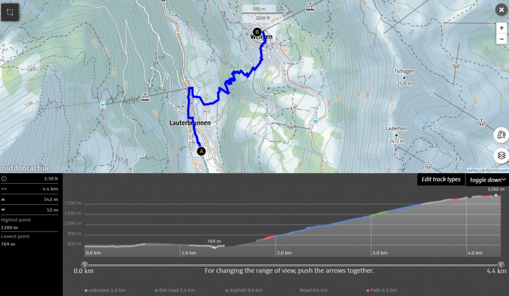
So in total, the hike is not that long, so if you are in a hurry or do not want to sweat that much in the Swiss Alps, it’s a perfect hike for you. Even though it’s not that long, it is beautiful. Very much.
So you should reach Wengen in under 2 hours, the hike is around 4 kilometers and the elevation gain is 500 meters. It’s not much, but it’s not little. So still pace yourself. 500 meters can be very hard if you do it fast or you are not in a very great physical condition.
Wengen is full of hotels, restaurants, shops, and many other things. If I were you, I would just go to enjoy some Swiss fondue, relax, drink coffee, and head back to Lauterbrunnen. The hike back shouldn’t be longer than 1h30 minutes. So the hike in total is under 4 hours, around 8-9 kilometers. But spend some time in Wengen, enjoy it 🙂 So the total experience will be longer.
If you’re in Wengen and looking for more adventure, check out these majestic hiking trails in Wengen.
4- Lauterbrunnen to Gimmelwald Hike
The hike to Gimmelwald and back to Lauterbrunnen is a bit longer, so you should prepare all day to do it. Better start early.
Gimmelwald is a very nice Swiss Alps village sitting at 1367 meters altitude and is the last village up there. After that: just huge mountains.
While going to Gimmelwald you are going to cross Mürren, another famous village in the valley. But after that, you must keep going until you get to Gimmelwald.
Let’s have a look at the map below:
So the hike is over 8 kilometers, takes more than 4 hours and you will gain around 900 meters in elevation.
Gimmelwald is a very small village, so just to be safe take all the water and food you need into a backpack. I don’t want you to get in trouble if no shops are open. Once I was in Mürren in the fall and couldn’t find any open shops.
Once you head back from Gimmelwald, some hiking up will have to be done, up to Mürren, but from there, it’s going to be all the way down. All hike shouldn’t take you longer than 7 hours and 16-17 kilometers in total.
5- Lauterbrunnen to Grütschalp Hike
Grütschalp is a rail station that connects Mürren and Lauterbrunnen. I think the best thing you can do from Grütschalp is to take a panorama way to Mürren. It is a very easy walk/hike to Mürren where you can enjoy the views of the Lauterbrunnen valley and white mountain peaks.
Ok, let’s have a look at the map below:
The hike itself is under 2 hours, under 4 kilometers and you will gain around 700 meters in elevation. But from there I really recommend you going to Mürren, you will not regret prolonging this hike. From Mürren, you can go down the same way the Mürren hike maps shows, no need to walk to Grütschalp again.
From Grütschalp to Mürren it is 5 kilometers and then from Mürren to Lauterbrunnen is around 6 kilometers, so the whole hike would be 15 kilometers. It’s really nice, especially when you can enjoy that panorama hike/walk.
6- Lauterbrunnen to Grindelwald Hike
This is the ultimate hike in Lauterbrunnen. It won’t be done in a day, but Grindelwald is a really nice place for you to visit. In this hike, you are going to outdo two more hikes in this list: a hike to Wengen and a hike to Kleine Scheidegg.
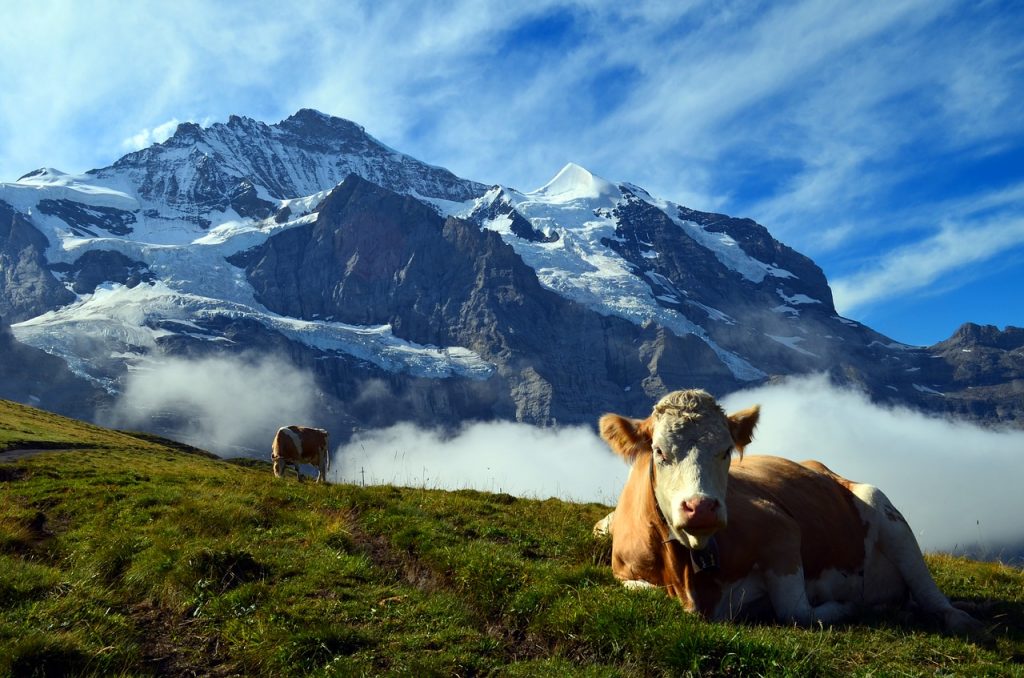
I think if you wish to have an ultimate adventure in Lauterbrunnen, that’s the way to do it. You will spend lots of time in the mountains, will meet hundreds of Swiss cows and will see a lot of different places. All in just a couple of days.
Ok, let’s have a look at the map below:
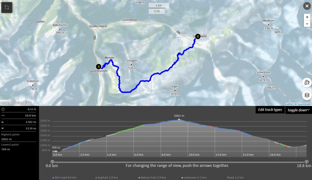
The first part of Kleine Scheidegg will be the hardest one as you will have to climb up for more than 4 hours. And you are going to gain a lot in elevation, so pace yourself in this part of the hike.
Once you reach Kleine Scheidegg I really suggest having a longer rest, have lunch, drink coffee or tea, despite the fact that another part of the hike is always down, it’s still not that easy as foot and joints are getting tired pretty fast once you walk just down and down.
If you feel that you are too tired at Kleine Scheidegg and still would like to visit Grindelwald, you can take a train from up there. They go quite often. As well, trains go up to Jungfraujoch from Kleine Scheidegg. 🙂
On the way from Kleine Scheidegg to Grindelwald you are going to pass through a couple of restaurants and quite a many meadows with cows, so that decreases pain if you get some.
The whole hike from Lauterbrunnen to Grindelwald will take you around 7 hours. Is it possible to come back on the same day? Yes. But that will be painful and very tiring. Very very tiring.
You must be in your top condition to get pleasure from such a long hike. 14 hours in the mountains is like 20 hours on flat ground in the Netherlands.
I suggest just spend a night in Grindelwald OR you can use public transport to come back to Lauterbrunnen. AS well, check out the best hikes in Grindelwald: Grindelwald trails. Maybe you will want to hike there the next day?
As well, it is possible to do Lauterbrunnen loop hike: you would have to hike to Gündlischwand from Grindelwald and then back to Lauterbrunnen, it is 16 kilometers, but much easier, much smaller elevation differences, so on the second day it’s perfect, not that tiring.
Lauterbrunnen has definitely a lot to offer to a hiker. If you can, you can spend all week in Lauterbrunnen and just do all of those hikes and I can assure you that each day you will be stunned by the views and surprised how can it be that beautiful every day.
Every day something new pops up, a new valley, a new peak, a new angle, a new path. It’s a really picturesque place there.
If you want to do it safely, please have a look at my Swiss Alps hiking tips. Always be safe, pace yourself, don’t hurry, have additional water and food.
If you have any questions about hiking trails in Lauterbrunnen, please let me know, I will do my best to help you.
Do not forget to follow my journey for more hiking tips and adventures:
Instagram: @golookexplore
Facebook: golookexplore
Youtube: golookexplore
Pinterest: golookexplore
Pin it for later