The Schladminger hike can be classified as moderate, although it has sections that can be pretty challenging. Therefore, you must understand all the information about the hiking trail before you embark on your travel.
You are in a better position when you know what to expect because you will prepare adequately for your journey.
The views which you are going to get are absolutely stunning and be ready to use your camera as your Instagram account is going to blow up.
Table of Contents
Where to Stay During Schladminger Hike
It is vital to note that this is a hut-to-hut hike (check out my hut-to-hut hiking experience in Switzerland), and it takes roughly a week to finish it, depending on your speed and the trip’s objectives. However, you are not limited in the number of days that you can spend on the hike. You can lengthen them or shorten them as long as you have fun and an amazing experience of this unique destination. During the trek, you will find charming mountainous huts with available rooms or private rooms that allow you to stay and enjoy the comfort of the mountains.
One aspect that attracts people to this hiking trail is that the huts usually serve unique food-focused to the local cuisine and international diet. Because of the unique geological features, this trail is rich in diversity, and you will see different fauna and flora, thereby making your trip memorable. There are a dozen waterfalls and tarns, and you will find these in the valleys and basins of the Schladminger trail. Depending on your level of fitness, you can hike this trail if you are well prepared. Here is our step-by-step guide on how to walk the Schladminger trail.
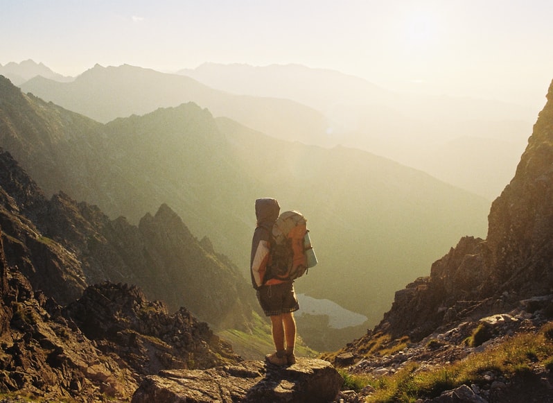
Explore the Hochwurzenhöhenweg to the Giglach Lakes trail
This is an 11.3 kilometers long hiking trail, and it is classified as moderate to difficult. The best season that you can climb this mountain is from June to September. This is important because you will visit the area once all the ice has melted and the flowers and plants are beginning to bloom effectively.
It usually takes six and a half hours to finish the trail, according to expert hikers. This part of the Schladminger hiking trail is the most popular location because many people have trekked it over the years, and they find it emancipating. However, it is good to note that it requires good physical condition, surefootedness, and maneuvering some of the uneven terrains.
Looking for alternative hiking trails in Austria? I’ve experienced the Olpererhütte hiking trail and it was a blast! Read my experience here.
The tour will take you through a stone pine forest and larch before opening up to the alpine trails. To get to this destination, you can begin from Kleine Wurzen, and from this point, you can see the summit with ease. You can get to the trail by following path 60, and this will take you to the ridge at Rossfeld. While in this location, the next summit of Guscchen is closer insight, and you can pass by the pine trees as you head downhill to Latterfußsattel.
The high trail will follow trail number 773 as it ascends slowly over the summit in Schneider. After that, the trail winds to the eastern side to Kammspitze. This location offers the best views of the lakes, and it is an excellent spot to take pictures. There is a hut in this place, and you can take a break and relax in the hut as you enjoy some local food.
Hike the fantastic Giglach lakes to Keinsprechthütte
This is a relatively short trail as it is only six kilometers long, and it will take you roughly four hours to finish it. However, it is classified as a moderate trail hence the need to be careful and be ready to deal with the changes in terrain and the changing weather conditions.
You will begin your trail around the Giglach lakes and head up to Vetterkar, an easy path. From this location, you can hike downhill through the alpine terrain and scree slope to the Krukeckscharte, which offers some of the most amazing views of the Schladminger region and the environs. Next, you will follow path 702 as you head through an old mining house. The region was a significant mining area in the recent past, and you should be careful about loose stone and gravel.
Further reading: Explore stunning Berlin High Trail
The path then climbs to Rotmandlspitze, which stands at 2,500 meters above sea level. There is an open road, and you can follow this path down, taking you to Keinsprechthütte. If you need some rest, this is the right destination where you can relax and unwind as you ponder on your next move.
Trek the Keinsprechthütte to the Gollinghütte hiking trail
This is the third stage of the Schladminger hiking trail, and it is nine kilometers long, taking you about five and a half hours to finish it. It is classified as a moderate hiking trail. Therefore, you expect some challenges during your hiking. The best time that you should visit this destination is from June to September.
The hike will take you from Keinsprechthütte through the valleys and uneven terrains to the Gollinghütte, a tributary of the lower valley in the area. This is the only part where you cross the Salzburg and Styria border twice. You will head to a terrain where there are alpine pastures and cows grazing.
There are rocky sections in this trail, and you should be careful when moving. Once you are in the area, you can cross the Trockenbrotscharte, and it is from here that you will see Gollingscharte. This is an ideal place where you can take a break, unwind and relax as you explore what the locals offer in meals. Don’t forget to enjoy the best Austrian coffee here!
Besides, you can learn more history about the country and the trail as well. As indicated, the best time to hike this trail is during the summer period because you can see everything you will not be challenged by the steepness of the mountains or the terrain.
Enjoy the Gollinghütte to the Seeleiten car park trail
This is easy terrain, and it is nine kilometers long, and you can traverse it in five and a half hours. The best time to hike this trail is from June to September when everything is cooled down, and you can see the hills and valleys in the region with ease. The trail begins at the Keinsprechthütte; from this region, you will follow route 702, leading you to a fork-like path. There are stone pine soils on the path, and you should have proper hiking boots to take on this terrain.
Further reading: Explore iconic Eagle Walk in Austria
The route takes you to Trockenbrotscharte, where you can have fantastic views of the slopes during the summer period. If you find that the high path is closed, you descend through the alternative route and still have the same difficulty level. The terrain can be challenging, and you must be well prepared to tackle it effectively. There are huts in this area, and you can take a rest before you continue with your journey.
Explore the amazing Klafferkessel to the Preintalerhütte hiking trail
This is the fourth stage of the Schladminger hiking trail, and it is 7.8 kilometers long and is classified as moderate. You can hike it in five and a half hours. The best time to go for a hike is from June to September. The mountain tour will take you to the high alpine landscape where you can see the most amazing views from the top of the mountains.
You will hike from Gollinghütte to Waldhornalm, located in the Research Valley. In this trial, you will see numerous mountain lakes, and it is a good experience because the blue clear turquoise lakes are photogenic. You can take pictures of the lakes with an amazing backdrop of the mountains.
Further reading: Karwendel High Trail is definitely worth checking
The Klafferkessel is unique because it has green mosses, and these are well distributed on the hiking trail, making the experience even more impressive. It would be best if you took the time to embrace nature and diversity as you hike the trail. The mountain lakes are still covered with ice throughout the summer period. The mosses and lichens are a fantastic addition as they add color to the lakes. The trek is downhill, and you can descend to Preintalerhütte.
Finish your hike with Preintalerhütte to Planai hiking trail
This is an easy trail, and it is twelve kilometers long, and it will take you around seven hours to complete. The best time to hike this trail is from June to September. This is when the harsh climate of the winter is over, and you can move from one area to another with ease. The path is secured with steel cables, and you will enjoy hiking in this terrain because you are sure that the landscape is well equipped.
Further reading: Majestic hikes in Wengen, Switzerland
Your safety is guaranteed, and knowing that this is your last step in your trip, you can hike it with enthusiasm. There is a variety of scenic impressions as you move along the hiking trail. As you walk, you will see the amazing Riesach valley and have a wonderful view of the Dachstein massif. The trail is exceptional, and you should check out all the tourist information before you embark on this trail.
In conclusion, the Schladminger trail is exceptional, and you will see a variety of things as you move from one trail to the next. You should not be limited to the trials indicated. You can try others as well.